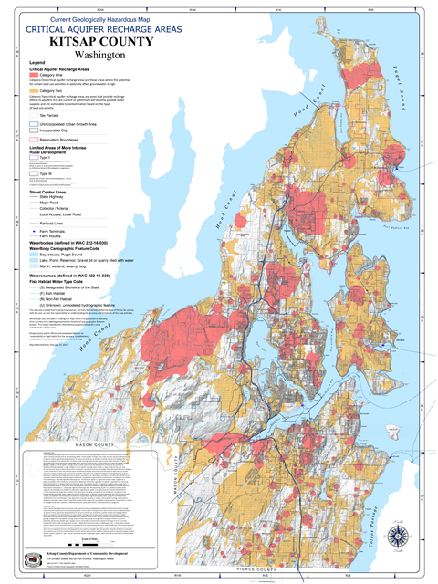
Community Development Maps/GIS

Current Planning and Regulatory Maps

Zoning Map

The designations, locations, and boundaries of the zones set forth in Title 17 Zoning, are shown on the zoning map of Kitsap County, Washington. The map and all notations, references, data, and other information shown are adopted and made a part of Kitsap County Code Title 17 Zoning.

​Comprehensive Plan Land Use Map

 The Comprehensive Plan Land Use Map show the land uses that are permitted by the Comprehensive Plan.  The Land Use Map is adopted as part of the Plan.  It designates the proposed general distribution, locations and extent of the uses of land for urban and rural uses, where appropriate, for housing, commerce, industry, recreation, open spaces, public utilities and facilities, agriculture, forestry and other uses.  The Land Use Map guides growth consistent with Urban Growth area boundaries and provides the capacity to accommodate adopted growth targets.

Shoreline Environment Map

​The Shoreline Management Act (SMA) Guidelines [WAC 173-26-211(2)(a)] require local shoreline master programs (SMPs) to "classify shoreline areas into specific environment designations. This classification system shall be based on the existing use pattern, the biological and physical character of the shoreline, and the goals and aspirations of the community as expressed through comprehensive plans" as well as the criteria in WAC 173-26-211.

Shoreline Environment Map Commissioner District 1 - North Kitsap

Shoreline Environment Map Commissioner District 2 - South Kitsap


Shoreline Environment Map Commissioner District 3 - Central Kitsap


​Planning Jurisdictions

 Kitsap County consists of the following Urban Areas:
Incorporated Cities:
Bremerton, Port Orchard, Poulsbo and Bainbridge Island
Unincorporated Urban Growth Areas:
Kingston, Silverdale, Poulsbo, Central Kitsap, Bremerton East, Bremerton West, Gorst and Port Orchard.
Reservations:  Port Madison and S'klallam
Limited Areas of More Intense Rural Development:
Type I:  Suquamish, Manchester, Port Gamble, George's Corner and Keyport
Type III:  Ecology Road, Streibel's Corner, Twelve Trees, Bond/Gunderson and Port Orchard Airport

Census Urbanized Area

 This map defines where varying amounts of impervious surfaces are allowed.
For sites within the Census-defined Urban Areas, or within the County-defined Urban Growth Areas, the creation (or cumulative addition of) 5,000 sq. ft. (or greater) of impervious surface area from pre-development conditions are considered major developments and require storm water mitigation through a Site Development Activity Permit (SDAP).  For sites outside of the Census-defined Urban Areas, or the Urban Growth Areas, the creation (or cumulative addition of) impervious surfaces that results in 5.0% (or more) of the development site being covered in impervious surfaces or the creation (or cumulative addition of) 10,000 sq.ft. of impervious surfaces from the predevelopment  conditions (whichever is greater) is a major development, and  requires storm water mitigation through a Site Development Activity Permit

Comprehensive Plan Maps by Commissioner District

​District 1 - North KitsapDistrict 2 - South KitsapDistrict 3 - Central Kitsap

Zoning Maps by Commissioner District

District 1 - North KitsapDistrict 2 - South KitsapDistrict 3 - Central Kitsap

Urban Growth Areas

​ ​Bremerton East

​ ​Bremerton West

Comprehensive Plan Land Use MapZoning MapComprehensive Plan Land Use Map​Zoning Map

​ ​Central Kitsap

​ ​Gorst

​​Comprehensive Plan Land Use Map​Zoning Map
​Comprehensive Plan Land Use Map​Zoning Map

​ ​Kingston

​ ​Port Orchard

Comprehensive Plan Land Use Map​Zoning Map​Comprehensive Plan Land Use MapZoning Map

​ ​Poulsbo

​ ​Silverdale

Comprehensive Plan Land Use Map​Zoning MapComprehensive Plan Land Use Map​Zoning Map

Natural Resource Maps

Critical Areas
This map depicts Critical Areas, as defined in Title 19 Kitsap County Code (Critical Areas Ordinance), and is for informational and illustrative purposes only (WAC 365-190-080).

This map includes:
• Wetlands (Chapter 19.200 KCC)
• Fish and Wildlife Habitat Conservation Areas (Chapter 19.300 KCC)- Streams, lakes, waterbodies ONLY
• Geologically Hazardous Areas (Chapter 19.400 KCC)
• Frequently Flooded Areas (Chapter 19.500 KCC)


This map does NOT include:
• Critical Aquifer Recharge Areas (Chapter 19.600 KCC).
Please see separate Critical Aquifer Recharge  Areas map.

This critical area applies primarily to commercial, industrial, and mining uses.
• Fish and Wildlife Habitat Conservation Areas (Chapter 19.300 KCC), other than streams and lakes.   Please see the Priority Habitats and Species maps and database provided by the Washington Department of Fish and Wildlife (https://wdfw.wa.gov/) for the most recent information on Class 1 and Class 2 Fish and Wildlife Habitat Conservation Areas.
This map may differ from the official critical areas maps for the incorporated cities within Kitsap County.  Please refer to the cities for more information.

Critical Aquifer Recharge Areas

Critical Aquifer Recharge Areas means those land areas that contain hydro geologic conditions that facilitate aquifer recharge and/or transmit contaminants to an underlying aquifer.  Critical aquifer recharge areas under this title may be established based on general criteria, specifically designated due to special circumstances, or based on scientific studies and mapping efforts.  Factors considered in the identification of critical aquifer recharge areas include depth to water table, presence of highly permeable soils (specifically Group A Hydrologic Soils), presence of flat terrain, and the presence of more permeable surficial geology.

Drift Cells

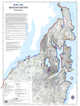
Littoral drift, or shore drift, is the process by which beach sediment is moved
along the shoreline. Drift results primarily from the oblique approach of wind-generated waves and can  therefore change in response to short-term (daily, weekly, or seasonally) shifts in wind direction. Over the long term, however, many shorelines exhibit a single direction of net shore drift. Net shore-drift is determined through geomorphologic analysis of beach sediment patterns and of coastal landforms.

Geologic Map Units

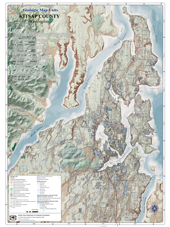
Surface Geology is used for regional spatial analyses and other digital applications and for providing a framework for planning and land management and evaluating geologic hazards and resources.

Streams

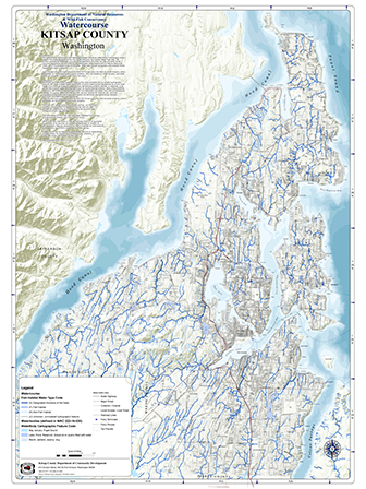
The Watercourse (WCHYDRO) and Water Body/Water Shoreline (WBHYDRO) Hydrography layers support the implementation of the new Forest Practices Fish Habitat Water Type Map. The primary purpose of the data is to aid in the application of timber harvest and other forest  practices regulations and activities by the Washington State Department of Natural Resources (DNR) within the forested areas of the state. Other uses include cartography and analysis where hydrographic data is required.
 
Also included here are areas where the Wild Fish Conservancy has field-surveyed streams, where accessible, for fish presence and overall condition. WFC will expand on these surveys, and these areas will increase in extent, likely every two years.

Streams and Surface Water

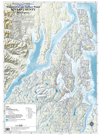
WCHYDRO and WBHYDRO together make up the most complete and up to date hydrography layer for the State of Washington. WCHYDRO contains watercourses represented as arcs or lines. These occur alone as single arc watercourses representing streams, ditches, or pipelines, or as centerlines through  water body polygons such as double-banked streams, lakes, impoundments, reservoirs, wet areas, or glaciers. WBWS (WBHYDRO) and WC (WCHYDRO) are edited daily and simultaneously; updates are posted weekly for internal DNR use and monthly for external use. Attribute interrelationships within WBWS (WBHYDRO) and spatial and attribute interrelationships between WBWS (WBHYDRO) and WC (WCHYDRO) are maintained.

​Soil Survey

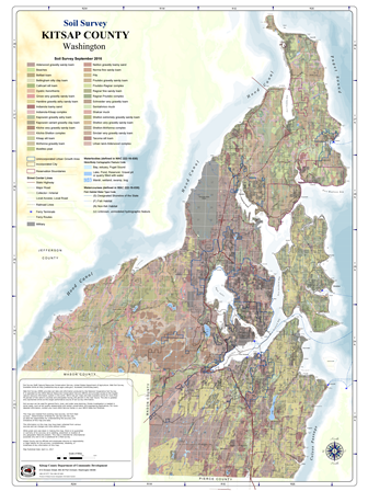
Information for SOILS data layer was derived from the Private Forest Land Grading system (PFLG) and subsequent soil surveys. PFLG was a five-year mapping program completed in 1980 for the purpose of forestland taxation. It was funded by the Washington State Department of Revenue. The Department of Natural Resources, Soil Conservation Service (now known as the Natural Resources Conservation Service or NRCS), USDA Forest Service and Washington State University conducted soil mapping cooperatively following national soil survey standards. Private lands having the potential of supporting commercial forests were surveyed along with interspersed small areas of State lands, Indian tribal lands, and federal lands.

​Geologically Hazardous Areas - Landslides

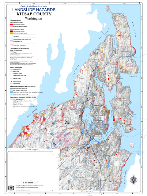
Deep Seated Landslide Inventory are polygons that represent the outline of landslide deposits, landslide toe, and landslide headscarp. Shallow landslide hazards which polygons show areas of high and moderate shallow landslide hazards.


​​Geologically Hazardous Areas -  Erosion

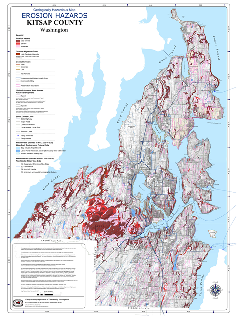
The data represents soil erosion hazards designated by the Natural Resources Conservation Service, Soil Survey for Kitsap County and the coastal erosion hazards for Kitsap County.  The ratings in this interpretation indicate the hazard of soil loss from off-road and off-trail areas after disturbance activities that expose the soil surface. The ratings are based on slope and soil erosion factor K. The soil loss is caused by sheet or rill erosion in off-road or off-trail areas where 50 to 75 percent of
the surface has been exposed by logging, grazing, mining, or other kinds of disturbance. The hazard is described as "moderate," "severe," or "very severe." A rating of "moderate" indicates that some erosion  is likely and that erosion-control measures may be needed; "severe" indicates that erosion is very likely  and that erosion-control measures, including revegetation of bare areas, are advised; and "very severe"  indicates that significant erosion is expected, loss of soil productivity and off-site damage are likely, and  erosion-control measures are costly and generally impractical. Identification of shoreline areas within Kitsap County that are subject to coastal erosion.

​​Geologically Hazardous Areas - Seismic

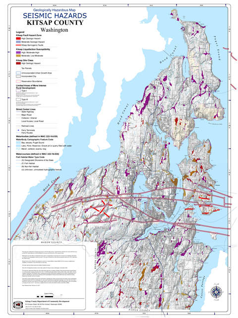
This map displays data that is a derivative of potential seismogenic fault data that was compiled as part of the Data Preservation Program of the Washington Division of Geology and Earth Resources in August 2013. These data represent the fault hazard zone where potential for fault rupture hazards could occur during an earthquake along the fault for Kitsap County. The purpose of the data is to represent areas in the vicinity of potential seismogenic faults.  The map also includes data that represents an update of Kitsap County's liquefaction hazard on recent geologic mapping completed for USGS 1:24,000 Quadrangles (Belfair, Burley, Eldon, Holly, Lofall, Olalla, Poulsbo, Seabeck, Suquamish, and Wildcat Lake). Existing liquefaction hazard data completed for the State of Washington at a scale of 1:100,000 was used for the remaining USGS Quadrangles for Kitsap County (Bremerton East, Bremerton West, Duwamish, Hansville, and Port Gamble)

Water Resource Inventory Area 15 Watersheds

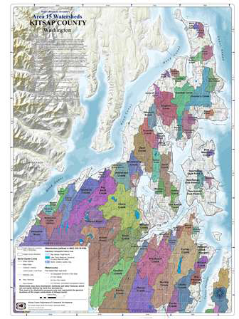
Water Resource Inventory Areas (WRIA) for Washington State at 1:24,000 scale. WRIAs were formalized under WAC 173-500-040 and authorized under the Water Resources Act of 1971, RCW 90.54. Ecology was given the responsibility for the development and management of these administrative and planning boundaries. These boundaries represent the administrative under pinning of this agency's business activities. The original WRIA boundary agreements and judgments were reached jointly by Washington's natural resource agencies (Ecology, Natural Resources, Fish and Wildlife) in 1970.  Watersheds may share headwater wetlands and other features which are not easily defined by hard-line boundaries. This map is for illustrative purposes only and represents the general locations of the major watersheds of Kitsap County

Federal Emergency Management Agency Flood Map

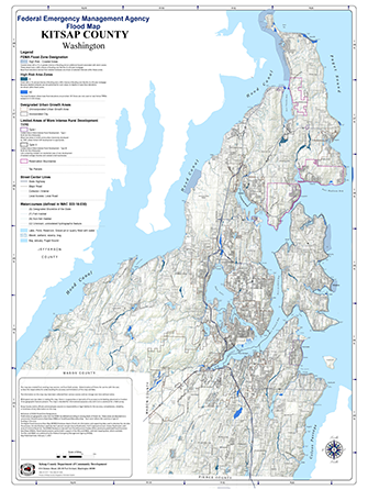
A Flood Insurance Rate Map (FIRM), Flood Boundary and Floodway Map (FBFM), and Flood Hazard Boundary Map (FHBM) are all flood maps that have been produced by FEMA. The FIRM is the most common map and most communities have this type of map. At a minimum, flood maps show flood risk zones and their boundaries, and may also show floodways and Base Flood Elevations (BFEs). The FBFM is a version of a flood map that shows only the floodway and flood boundaries. The FBFM is no longer produced; current FIRMs include all of this information. The FHBM is an older version of a flood map and is based on approximate data.

Miscellaneous Maps

Areas of Prohibited Shooting

The intent of this map is to show any areas designated as an area where a discharge of a firearm is prohibited.  Kitsap County Code, Chapter 10.25 described by 10.25.020 Discharge of firearms - Areas where prohibited.  It is unlawful to shoot, fire or explode any firearm, firecracker, firework, torpedo or explosive of any kind or to shoot or fire any air gun, BB gun, bow and arrow or use any slingshot in any park
except the park director may authorize archery, slinging, fireworks and firing of small bore arms at designated times and places suitable for their use. Kitsap County Code, Chapter 10.12.080.

Burn Ban Maps by Commissioner District

District 1 - North KitsapDistrict 2 - South KitsapDistrict 3 - Central Kitsap

 Links

For Past Planning and Regulatory Maps

Click Here.... 


Find Maps from all the Departments of Kitsap County at:​
Kitsap County Information Services GIS Division


CONTACT

Department of Community Development

Planning and Environmental Programs

(360) 337-5777 (Kitsap 1)

compplan@co.kitsap.wa.us


MAILING ADDRESS

614 Division Street - MS36
Port Orchard, WA 98366

Office Location 

619 Division Street
Port Orchard, Washington


STAY INFORMED


Subscribe to receive future notifications


 Disclaimer

These maps were created from existing map sources, not from field surveys.  Determination of fitness for use lies with the user, as does the responsibility for understanding the accuracy and limitations of these maps and data.

The information on these maps may have been collected from various sources and can change over time without notice.

While great care was taken in making these maps, there is no guarantee or warranty of its accuracy as to labeling, placement or location of any geographic features present. These maps are intended for informational purposes only and are not a substitute for a field survey.

Kitsap County and its officials and employees assume no responsibility
or legal liability for the accuracy, completeness, reliability, or timeliness of any information on these maps.